
 Friday, Jan 5th 2007
Due to spending so much time in the saddle and on the road, without convenient access to the Internet, I now had four days’ worth of pics and associated explanatory captions to post to my blog-journal. This would be no easy task, especially when uploading to two separate sites, namely: (1) http://keithoops.blogspot.com; and (2) http://keithooper.smugmug.com/gallery/2198628. There are some technically convenient reasons for maintaining two online photo albums, which I won’t bore you with now.
But our hostess in Ohope, Sue, kindly let me use her own high-speed connection, just for a while, but enough time to make a Skype connection with the folks back home, and John Dubya down in Otematata, SI. Regrettably, therefore, we had to backtrack a little into the bigger township of Whakatane in order to find another broadband connected internet café.
Some two hours later, at around 1:15pm, we were finally ready to re-fuel and get under way again to our next destination of Gisborne City; huddled at the top end of Poverty Bay, which is itself located on the south-eastern coast of North Island’s East Cape.
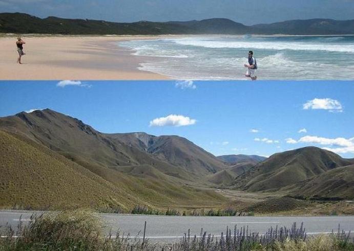
So, after passing back along the road through Ohope that leads on to the township of Opotiki, we then turn right and head southwards towards the Waioeka Gorge Scenic Reserve; a natural gateway that leads to the City of Gisborne. After a while the mountainous hills through which the Gorge runs came into view.
 The run through the Gorge, which mostly meanders alongside the east bank of the Waioeka River, was indeed scenic and conjured-up memories of previous motorcycle rides through Austria, Wales and more recently Scotland.
 By around 4:30pm we enter and pass through Gisborne and make straight for the harbour at the far end of the main shopping strip, working on the theory that, ‘where there’s water, there’s bound to be life’. On the way it was indeed good to see a few buildings that were constructed before 1960!
 But the only forms of life we found (as we know it, Jim .. :o) were a few quayside fisherman chancing their luck at hooking a fresh fish dinner, and a few more aggressive shitehawks (a Cornish word for ‘seagulls’.. :o) on the usual scrounging search for whatever morsels came their way; all of whom, incidentally, were having quite a bit more success than the less fortunate fishermen
 We leave the harbour and take a short 5-minute slow ride onto the beachside Napier-bound road, which we will need to pick-up the following day – as Napier is our next destination – and are drawn to the inviting long curvaceous sandy beach, where for the first time since leaving home (Newquay in Cornwall, England) I see some real Pacific region surf; plus a couple more sets of curves that are gracious enough to give me a warm and friendly smile as I press the camera’s shutter button. I successfully manage to resist the temptation of then raising a Roger Moore-type eyebrow and saying in return, “Nice tits” … ;o)
A further five minutes later and we’re booking into yet another super self-contained motel lodge unit, situated just 200 metres from the beach that we had just left and 10 minutes walk from the centre of the City.
BUT if any Kiwis end up reading this and see my photos, then I want to show them what REAL Atlantic surf looks like; taken by yours truly at one of our local surfing spots at Fistral Beach, Newquay, Cornwall. See below:


