"Reloaded"


Some spectacular vistas of New Zealand

Some spectacular vistas of New Zealand
These are just a tiny sample of the views I experienced during my last visit to New Zealand in late December '05 and January '06. So it is easy to see why I am drawn back to this beautiful country ...

Saturday, March 31, 2007

Saturday, March 17th

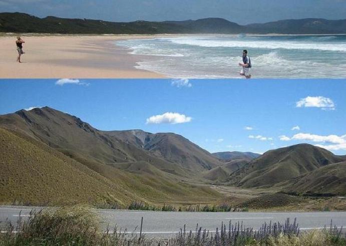
I’m away from Manapouri by 10:00am, there’s no rush today. The plan is to simply get myself eastwards across to Queenstown, which nestles in a northeast corner of Lake Wakatipu. It’s a young-at-heart vibrant town - the “Adventure Capital” – and is one of the world’s leading mountain resort holiday destinations. I have arranged to stayover for just one night with a new acquaintance, Stephen, who I met by pure chance whilst riding down the northeast coastal section of SH1 from Blenheim to Kaikaura during the late afternoon of Wednesday, 28th February.

But as I have plenty of time on my hands I start the day’s ride by a short 20 km (13½ mile) diversion northwards to Te Anau Township in order fill up the tank with some cheaper premium gas, update my blog, Skype the reles back home, and grab some brunch.

Stephen + Lisa (missus) won’t be back in their Queenstown home until around 5:00pm in any case, so as I say, there is plenty of time to make the 180 km (112 mile) journey, which should take no longer than 2½ hours .. max.

Chores done-and-dusted, and I’m away from Te Anau by around 1:00pm.

After travelling around 30 km (18½ miles) eastwards along State Highway 94 I pass a road sign indicating a gravel track to ‘Mavora Lakes - 38 km’ just to the north. Should I go? Or should I continue along SH94? ‘Buggerit, les go’ I think to myself ‘wos a bidda harmless gravel? - I’ve done enough of it not to be worried’ and ‘I got plenny a time on my hands’

So I turn the Trannie around and embark upon this benign [?] riding surface towards South Mavora Lake

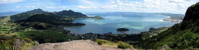
Around 45 minutes later I arrive there ...

.. and make my way across to the southern lakeside shore ...

.. observing and taking-in protocol and the local by-rules in the process

The lake and surrounding mountains remind me sooooo much of the rugged and beautifully breathtaking Scottish Highlands

So I decide to go deeper into the wooded lakeside, where I leave the gravel, and take whatever comes my way

Try negotiating this stuff on a fully laden 700 lb (318 kg) ST1300 Pan-European ... ?!

I don't think so .. Mr Jones!

But after a while I'm back to the shoreline. Fantastic wilderness - Surreal .. dreamlike

Now just how am I gonna turn the bike around? .. :-(

But after a scramble, I do turn around and start heading south towards 'civilisation' [?]. There's hardly a soul around; just me, the V-twin, and some pesky sand flies

30 km (18½ miles) later I'm skipping over the corrugated gravel at speeds of 50, 60 & 70 km/h (31, 37 & 43½ mph). Boyoboy .. have I got this gravel-stuff licked .. or wot John?

-------------------------------------

Soon I see the tar-sealed surface come into view 'that's early ..? I think to myself. Just a 100m away from the smooth surface I'm still picking my line and starting to accelerate towards the black stuff. Then, suddenly .. I'm staring a small potential disaster straight in the face!

I hit a washed-out, recently re-graded, stretch of new gravel that catches and retains my line in a deep [and growing deeper .. yikes!] tyre track which is gullying me into the RH roadside ditch that's full of large stones and small boulders. I can't seem to steer out of this deepening tyre-created gully. So I have four choices:

1. Get over the LH edge 'hump' of gravel. No, that's not for me, I'm no scrambler
2. Brake real hard. No again, I decide. On this loose surface the non-ABS assisted braking system will instantly lock-up the wheels. No straight line stoppage with this option, I'll be all over the place - and down within a second
3. Attempt a 'controlled drop'? .. I don't think so, that's just another name for a 'crash' in my book!
4. Shut down the throttle? or do I retain my speed and traction? Take my chances with wherever this gully takes me. A split-second decision is required

I choose a wishy-washy half-hearted number 4.

I'm just 40-50m away from safety - we then hit a large stone - basketball size. As a result ...

.. the Trannie and I go down.

Bugger! So near and yet still so far.

Friday, March 16, 2007

For Your Eyes Only ... Followed by a Doubtful Mood

Friday, March 16th

I awoke this Friday in Manapouri to a mixed bag of weather. This is my first view of the morning at 07:49am, looking northwest .. AWAY from the rising sun. Pretty - but weird, huh?

So it's onto the bus to take the short ride west to Pearl Harbour wherein I ...

.. and my fellow passengers, embark aboard the first of today's two small cruising vessels; the initial one takes us across Lake Manapouri where we all disembark at West Arm.

We then travel underground by coach to see the Manpouri Power Station machine hall. It looks like something out of a James Bond movie, doesn't it?

A tunnel network leading to a huge hall all of which have been hewn out of solid rock ...

.. with seven giant power generating machines humming away beneath the stone floor

Then it's over Wilmot Pass, again by coach, stopping along the way to experience some of Fiordland's most dense rainforest, where at Deep Cove we take passage on the second of today's vessels to cruise around Doubtful Sound for three-hour; taking in some dramatic scenery.

Our skipper provide a detailed commentary and point out highlights

At first view, looking at these pictures, it might appear disappointingly overcast. That it was, with rain and drizzle perhaps spoiling the day.

But not so - as whatever mood Doubtful Sound is in brings a new and different dimension for the visitor. It was a day full of shadows and mystery. The rain brought with it some spectacular waterfalls which otherwise, on a fine day, would not have been present


I'm glad I went to wet and moody Doubtful Sound on this particular Friday .. :o)

------------------------

Lake Manapouri stats:-

Area: 142 sq km - fifth largest lake in New Zealand
33 islands
Shoreline length: 170 km
Catchment: 1,388 sq km
Maximum depth: 444m - second deepest lake in New Zealand (Deepest is Lake Hauroko with max depth of 462m)
Natural mean height above sea level: 177.8m
Deepest part below sea level: 266m
Average annual rainfall at West Arm: 3280mm

No Place Like Home

Thursday, March 15th

Yesterday, Wed-14, John and I did manage an invigorating 300km (188 mile) afternoon's ride-out on the bikes in a broad easterly direction, with the turnaround point being the coastal city / large town of Oamaru. The weather conditions were cold, but with plenty of layers of cover-up clothing it was an enjoyable run that ended with a skirting of Lake Aviemore, which returned us to Otematata by around 6:45pm. I was, of course, following John's tail-light, as he knows these roads intimately. But I can indeed say that 'I kept up with the Joneses' .. no problem .. ;o)

But it is time to leave my good mates John and Pip, who have both been nothing less than magnificent with their altruistic support and companionship throughout my endeavours to tour New Zealand on two wheels. Friends like these are rare in a lifetime.

I do hope John can 'figuratively' join me during my furthet travel adventures, albeit from thousands of miles away; and especially throughout the course of my Merrycan trip this [northern hemisphere] summer. Should be okay, as distance has hitherto never proved a barrier between us, even going way back as far as last September '06, when we first started communicating.

One more time: Thanks again, to John & Pip .. ;o) :o)

So by 10:30am I leave Otematata and immediately turn west onto SH83 where I head back towards the mountains and the nearby Alpine Lewis Pass, which will lead me to today's ultimate destination of Fiordland in the far southwest region of South Island.

The mountains still carry the remnants of the last couple of day's bad weather on their caps; the oncoming views are indeed a spectacle to behold


After negotiating the Lewis Pass, I fill-up with a drop of the good stuff - BP's unleaded 98 octane - at Cromwell Township, before running down Kawarau Gorge ...

.. and up the other side; after which a vicious wind picks-up that gives me more than little to think about as the Trannie and I are blasted around the road.

Despite the battle against the wind, and after a bite to eat and a couple of phone calls later in Frankton, Nr Queenstown, I finish my day's journey at around 5:00pm in the little lakeside town of Manapouri. And find all I need ...

.. including cover from the elements for my little steed; all-in at just NZD $40 (£14.38) per night. So I shall stay here in Manapouri for the next two nights that will include the whole of tomorrow, Friday, 16th.

Then the wind picks-up to a strong to severe gale force hoolie. I want the warm sunshine back please! And I'm left wondering - what weather conditions tomorrow will bring? as I drift off to sleep.

My progress during the second tour around South Island, thus far

Wednesday, March 14, 2007

Every Day is a Winding Road


Wednesday, 14th March

With fast and unlimited wireless access to John’s internet facility, I take the opportunity to upload my fourth short video to the world wide web.

I hope you enjoy this embedded video, which as before, you can view and still stay here, on this blog, by clicking twice on the small forward play-arrow located in the very bottom left-hand corner of the above snapshot picture; or

it can be viewed in a slightly higher resolution by clicking on this link

A Touch of Winter

Monday 12th & Tuesday 13th March 2007

Mon-12-Mar

The recent forecasts and my observations predicting bad weather 'just over the horizon' and heading our way are proving correct. Today, Mon-12-Mar, the temperature dropped by around 10ÂșC to the mid teens Celsius.

Nevertheless, I am in the Mount Cook area specifically to revisit the BIG surrounding mountain ranges; so for the first time since Thursday-18-Jan (when we were way down in the very far south of South Island) I decide to zip the quilted liners into my riding jacket and trousers before starting the 50 km (31 miles) westward from Tekapo to The Mount Cook Visitors' Centre, which is located at the southern end of neighbouring Lake Pukaki.

When I arrive at my destination, just 40 minutes later, the cloud cover is spoiling my photo opportunity .. :o( ...

Unlike last year at the same spot .. :o)

So I move closer to Mt Cook via the right-hand, and much less used, eastern bank ...

.. and yet further north up the eastern bank along the deserted gravel track. But it's still hopeless .. :o(

So I head back south to around the mid-point of Lake Pukaki, where I turn left and return to Tekapo by crossing over the lonely, unsealed, windy and cold, Braemar Road, which runs along the southern slopes of Mount Cox.


---------------------------------------

Tue-13-Mar

I still regularly chat to John [Jones] through the media of video Skype calls, landlines and our cell phones. In view of the inclement weather, Johnny invites me to hold-up at his-and-Pip's place for a couple of days, before I head southwest again towards Queenstown and the Fiordland region.

The time is 10:00am and it's back west and south for 90 km (56 miles) in a bitterly cold and rainy SW wind sweeping up from Antarctica, via the Mt Cook Visitors’ Centre where I take another picture during a brief break in the rainfall, before arriving at the Jones' household by around midday.

It's good to see John and Pip again; almost like arriving 'home'

The current (as at Wed-14-Mar) South Pacific regional pressure chart. Notice the tightly-packed cyclonic isobars sweeping freezing cold conditions up from Antarctica

But there is a fair weather 'window' predicted for this Friday, 16th March. This is an important factor in my plans for the imminent future - (to be explained later .. :o)

Sunday, March 11, 2007

West to The Cloud Piercer

Sunday afternoon, March 11th

1:00 pm. It's time for me to leave Christchurch, I reckon, and head-out west again towards the Southern Alps - and the Mount Cook area in particular. At 3,496m or 11,470 ft, Mt Cook is New Zealand's tallest mountain; and is also known as Aoraki 'The Cloud Piercer'.

Around halfway through the ride, looking back over my left shoulder towards the southeast, I run along the bridge that crosses the Rakaia Bridge near the ski resort of Mount Hutt and notice some locals [probably] are enjoying the mid-afternoon late summer sunshine.

Progressing still further along the 230 km (143 mile) westward trip to my next intended stopover destination of Lake Tekapo, I observe the cloud cover thickening as it attempts to climb over the Alps from the West Coast, and the Tasman Sea beyond. It does look as though the forecasters might have correctly predicted a change in the weather to more unsettled conditions arriving from the west.

I arrive at Tekapo by around 5:00pm.

Later during the evening, towards dusk, I go (unusually for me :o) for a walk and take-in the stillness and tranquillity of the Lake's surroundings.

But turning around and strolling back to my digs, the cloud cover still looks threatening. There's buggerall, however, that I can do about it; I shall just have to take whatever comes my way, after what has been a wonderfully settled spell of weather for around the last month or so.